|
Maps, Greece and History By Jason C. Mavrovitis |
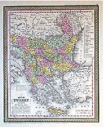
We wandered from shop to shop, stopping at a window display of photographs, autographs, documents and letters of the Confederacy, and other Civil War memorabilia. The shop was apparently one of several owned by a chain of stores named Antiquities. The material exhibited was interesting, so we went in to look around. In the back of the store was an area with maps both on the walls, and in vertical stacks in the room's center. Most of the maps were of the Confederacy, and its states and cities. Sprinkled among these were a few maps of Europe, the middle-east, Africa, and other regions. As I looked through the vertical stacks I came across the map shown above : Map of Turkey in Europe together with the Ionian Islands, published in 1850. It intrigued me. I searched the map for the city of Kastoria to no avail. Kastoria is located in the mountainous Macedonian region west of Thessaloniki and was still, in 1850, part of Turkey. My father was born in a small village named Mavrovo, to the east and across a mountain lake from the city of Kastoria. Disappointed at not finding Kastoria, I was about to put the map away. But, before doing so, I took the map close to a lamp to read the names of the cities on the western shore of the Black Sea. There, in small letters, was Sizeboli, which is the Turkish name for today's Sozopol in Bulgaria. Prior to 1881, when it was in the Turkish Empire, and for more than one thousand years before then, the Greeks who had inhabited the small, seaside-city, knew it as Sozopolis. It was the city of my mother's birth. 1 “Map of Turkey in Europe together with the Ionian Islands,” from the New Universal Atlas, (Philadelphia, Pennsylvania: Thomas, Cowperthwait, & Co., 1850), page 62. (12”x 9.7”, original color) Next Page: Windows into the Past (Posted August 2003) For more information about the author, see his biographical sketch under the Contributing Authors' section of HCS, or visit the author's website at http://www.goldenfleecepublishing.com. Mr. Mavrovitis has written a number of fine articles for HCS which readers can browse or read at the URL http://www.helleniccomserve.com/archivemavrovitis.html. 2000 © Hellenic Communication Service, L.L.C. All Rights Reserved. http://www.HellenicComServe.com |