|
I had recently received a letter from a Bulgarian graduate student who had visited Sozopol for me to conduct family research, and was therefore even more interested in this mid-19 th century map. It was modestly priced, so I purchased it, had it shipped to my home in California, and once framed displayed it on a wall of our entrance foyer.
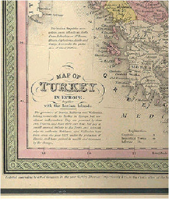
prises seven islands viz. Corfu, Paxu, Lefcathiaor St. Maura, Ithaca, Cephalonia, Zante, and Cerigo. It is under the protec- tion of Great Britain. The provinces of Servia, Moldavia and Wallachia, belong nominally to Turkey in Europe, but are almost independent. They are governed by their own Princes, and have their own laws, but pay a small annual tribute to the Porte, and acknowl- edge its authority. Moldavia and Wallachia have been since the year 1829, under the protection of Russia, and have gained by wealth and resources, by the change. I learned that antique maps are more than attractive wall decorations. They are documents that record the geopolitical reality of their time. In 1850, Great Britain controlled the Ionian Islands, having succeeded to their rule following centuries of control by the Byzantine Empire, the Venetian Republic, France, Russia, and France, yet again. In the end, Great Britain succumbed to increasing demands on the part of the Greek population of the islands for enosis, or union with Greece, and finally ceded the islands to the Greek Kingdom in 1864. Serbia became a fully independent state in 1878, at the same time that the principalities of Moldavia and Wallachia were merged into the new state of Romania. These changes came about as a result of the Treaty of San Stefano that ended the Russo-Turkish war of 1877-78. Russian forces had reached the Sea of Marmara, and, but for the intercession of the Great Britain, would have taken Constantinople. The 18th and 19th century histories of Serbia, Moldavia, and Wallachia are part of the drama of the decline of the Ottoman Empire that resulted, after more than a century, in the states that exist in the Balkans today.
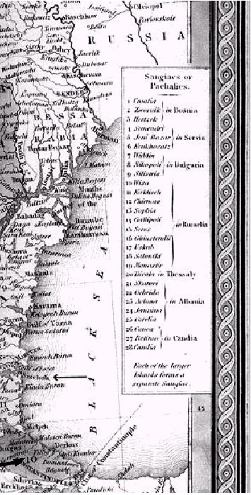
A Sangiac, in the nineteenth century, was a sub-province of a larger administrative region named Vilâyet (governed by a Pacha, hence also called a Pachalic 2 ). Identif ied by the arrow in the section to the right is the small city that interested me especially: Sizeboli. The map shows it to be in Sangiac #11, which is named Kirkliseh, and contained in the Vilâyet, or Pachalic , of Rumelia. In 1878, following the Russo-Turkish war, Rumelia was made an independent province, subject to the Sultan in Constantinople, but governed by an Orthodox Christian. Within three years it was annexed by the new state of Bulgaria, and was thus removed from under the Ottomans. Nonetheless, Sizeboli, or Sozopolis, was essentially still a Greek city, as it had been since its founding in the 7th century B.C. by Greeks from the Ionian city of Miletos , who originally named their colony Apollonia Pontika. I searched on the internet for websites and books about maps, and was rewarded with a wealth of reference material. My first purchase was the book Antique Maps, by Carl Moreland and David Bannister.3 Unfortunately, the book made mention neither of Thomas Cowperthwait nor of my map. It did contain a lot of information about antique maps, biographies of mapmakers, and a good bibliography. The internet search also produced a list of map dealers in Germany, Holland, Great Britain and the United States.One of these was the Argosy Bookstore on East 59 th Street in New York City. 2 Differences in spelling, e.g., pasha vs. pacha or pasa, and are common in texts produced at different times and by different writers. 3 Carl Moreland and David Bannister, Antique Maps, 3rd ed. (London: Phaidon, 1993). Next Page: An Incomplete Geography |